PROJECT: Clarence Creek Hydrology and Hydraulics Modelling
CLIENT: South Nation Conservation Authority (SNC)
NUMBER OF YEARS DEALING WITH CLIENT: +/- 3 years
DESCRIPTION OF PROJECT:
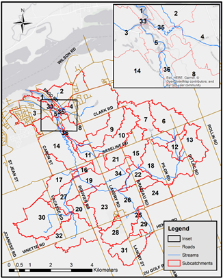
- Water’s Edge was retained by SNC to develop hydrologic and hydraulic models of the Clarence Creek watershed (east of Ottawa, Ontario) for the purpose of updating the floodplain mapping through the watershed.
- LiDAR data combined with the results of a previous bathymetric survey of the creek were used to delineate subcatchments and establish channel geometry.
- Water’s Edge has created a HEC-HMS model of the Clarence Creek watershed based on catchment boundaries from the hydro-conditioned DEM (prepared by Water’s Edge), drainage directions and drainage nodes with the parameters provided by SNC and those obtained through background review.
- A HEC-RAS model was developed for the main branch of Clarence Creek and its main tributary, Pilon Creek, based on available channel geometry, roughness parameters and flow rates from the hydrologic modelling component in order to determine water surface elevations for flood line delineation.
- A total of ten design storms were modelled.
SERVICES PROVIDED: HEC-HMS and HEC-RAS Modeling for Floodplain Mapping
DATE OF PROJECT: 2018