PROJECT: Chippewa Creek Floodplain Mapping Project
CLIENT: North Bay-Mattawa Conservation Authority
NUMBER OF YEARS DEALING WITH CLIENT: +/- 10 years
DESCRIPTION OF PROJECT:
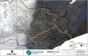
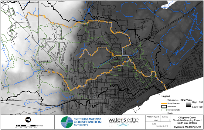
- Water’s Edge was authorized by North Bay-Mattawa Conservation Authority (NBMCA) to provide technical and engineering services to update the existing floodplain mapping of Chippewa Creek and two of its major tributaries, Eastview and Johnston Creek in the City of North Bay.
- Water’s Edge staff collected LiDAR data and processed the data for hydraulic modeling and mapping uses.
- A hydrologic model was built for the Chippewa Creek watershed using HEC HMS.
- A HEC-RAS model was produced to determine the water surface elevations for the various design storms.
- Spills between subcatchments were modelled with flow optimizations to reflect the flow volume moving between reaches.
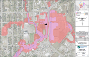
- Floodplain maps were then produced using the HEC-RAS results according to Provincial and HCA standards.
- Water’s Edge subsequently undertook 2D modelling of the lower portions of the watershed within the urbanized area to model spills.
SERVICES PROVIDED: HEC-HMS and HEC-RAS Modeling for Floodplain Mapping
DATE OF PROJECT: Fall 2018-Review