PROJECT: Stoney Creek and Battlefield Creek Flood Line Mapping Study
CLIENT: Hamilton Conservation Authority (HCA)
NUMBER OF YEARS DEALING WITH CLIENT: +/- 15 years
DESCRIPTION OF PROJECT:
- Water’s Edge was retained by HCA to model the floodplain for the Stoney and Battlefield Creeks watershed.
- Water’s Edge determined flood flows for a range of period floods for existing and future conditions.
- Water’s Edge calibrated, verified, and validated modelling to satisfy the HCA FPM Standards.
- Water’s Edge completed a sensitivity analysis of peak flows and runoff volumes to key model parameters and compare them to previous modeling results for a range of design storms at key locations.
- A HEC-RAS model was produced to determine the water surface elevations for the various design storms.
- Spills between subcatchments were modelled with flow optimizations to reflect the flow volume moving between reaches.
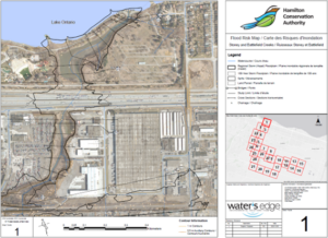
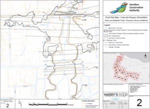
- Floodplain maps were then produced using the HEC-RAS results according to Provincial and HCA standards.
SERVICES PROVIDED:
- Topographic Survey,
- Hydrology & Hydraulics,
- Floodplain Mapping,
- AutoCAD
DATE OF PROJECT: February 2019 – ongoing


